Back in 2005, I first saw Google Earth and called it back then the 'killer app for Geography teachers'. It offered the chance to see the world in a new way, and to visit any place that you might be studying. To begin with, the quality of the imagery was not great once you moved away from the main inhabited parts of the USA, and certainly the UK, where Norfolk was covered with clouds for the first few years....
Despite this, I could see the potential and got in touch with someone at Google to suggest that they needed to have some decent Geography resources created (to some extent I'm still waiting for them....)
Dennis Reinhardt gave me a free PRO license for a year and I got to work exploring the world and seeing what was possible. I created a blog, and also put together a presentation for the 2006 SAGT Conference. I also applied for an Innovative Geography Teaching grant from the RGS-IBG for a project I called 'Earth: a Users' Guide' and these two events became my Google Earth Users Guide blog, which has been around since 2006.
Since then of course, Google Earth has gone through quite a few incarnations and been added to by Google Maps, Google StreetView and the various other Google tools that can be applied to mapping the world.
In the last year, there is also a new option for exploring the world and doing what might be called GIS work. This is ArcGIS Online. It's a cloud-based version of what used to be expensive and powerful software, and over time, some of the features are being added to the free tool. In recognition of the shifting focus towards a joint use of these two tools, I've changed the header of the original blog (though the name will remain).
Also added the resources for Digimap for Schools which I have written, along with Paula Owens and also for MapStream.
Visit the Google Earth User Guide blog for more on this...
That's not to say that I don't still use Google Earth a lot, and just been reading about it, and creating some new materials for a project I'm involved in.
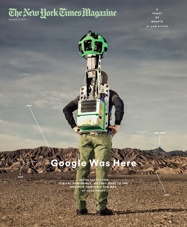
This article from the December 2013 New York Times Magazine is well worth reading as it explores Google's focus on mapping as a way of ensuring that their digital offerings all 'work'.
Magazine cover image: Copyright: New York Times / Dan Winters
Despite this, I could see the potential and got in touch with someone at Google to suggest that they needed to have some decent Geography resources created (to some extent I'm still waiting for them....)
Dennis Reinhardt gave me a free PRO license for a year and I got to work exploring the world and seeing what was possible. I created a blog, and also put together a presentation for the 2006 SAGT Conference. I also applied for an Innovative Geography Teaching grant from the RGS-IBG for a project I called 'Earth: a Users' Guide' and these two events became my Google Earth Users Guide blog, which has been around since 2006.
Since then of course, Google Earth has gone through quite a few incarnations and been added to by Google Maps, Google StreetView and the various other Google tools that can be applied to mapping the world.
In the last year, there is also a new option for exploring the world and doing what might be called GIS work. This is ArcGIS Online. It's a cloud-based version of what used to be expensive and powerful software, and over time, some of the features are being added to the free tool. In recognition of the shifting focus towards a joint use of these two tools, I've changed the header of the original blog (though the name will remain).
Also added the resources for Digimap for Schools which I have written, along with Paula Owens and also for MapStream.
Visit the Google Earth User Guide blog for more on this...
That's not to say that I don't still use Google Earth a lot, and just been reading about it, and creating some new materials for a project I'm involved in.
This article from the December 2013 New York Times Magazine is well worth reading as it explores Google's focus on mapping as a way of ensuring that their digital offerings all 'work'.
Magazine cover image: Copyright: New York Times / Dan Winters
Comments
An interesting post about ArcGIS. I've just signed up and attended some training at ESRI HQ in July. Can definitely see the benefits of using ArcGIS Online over Google Earth. However, I can see that training is definitely needed for ArcGIS Online to be used effectively. We only covered the surface of what it can do! It made me wonder if Google Earth is actual GIS because of the lack of functions in comparison to ArcGIS Online. Wonder what your thoughts are?
Yes, ArcGIS Online is very powerful and I've started to delve deeper as time permits. Google Earth was never really GIS, but has been used as such in schools and OFSTED reports seemed to back up the view that if used to display data this was enough.
The ability to query software and get answers to questions is what makes the difference. Recent additions to AGXO such as the heat maps and other features are going to make this a really powerful tool for schools.
You'll find more information over on my dedicated blog:
http://googlearthusersguide.blogspot.co.uk/
Look forward to seeing what you do with the tool - summer is a good time to spend some time with it... although it's also a good time to go to the beach and drink cider...
Best wishes
Alan
I'm definitely an ArcGIS Online convert following the training. The biggest issue I find, from what interviews I've done with people, are the price and the training. Although when I inform them it's now only £100 this isn't much of a problem. I think teachers are concerned about how to use new software like this and it seems that good GIS is in a minority of schools. However, there seem to be more and more useful websites and blogs out there making life easier ! (Thank you!)