And you can also use them even if your name isn't Philip....

Go HERE to download the XLS file that you'll need to create your MiniGeog.
You'll need to enable the macro that it contains to do the painting by numbers magic.
This is a mini-pixellated image in a 10x10 grid - a little creative challenge for you and your students...
Here's the instruction sheet.
Why not have a go at making:
- a mini landscape
- a physical or human feature
- a map symbol
- the outline of a country
- a local landmark
If you want a challenge sheet, then here are some things that you could have a go at.
Could you please screengrab the 10x10 MiniGeog section of the XLS and send them to me / tweet them with the hashtag #minigeogs
Here's a few examples that I got from the Wayback Machine archive of my classic GeographyPages, which had over 5 million page views in their time...
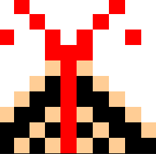


Thanks to Val Vannet, Helen Nurton, Victoria Ellis and Noel Jenkins for these back in the day....
Now minigeog on...

MiniGeogs was one of my favourite projects that I thought of when building the GeographyPages website. It was created back in 2005, with the help of FatMax.
Go HERE to download the XLS file that you'll need to create your MiniGeog.
You'll need to enable the macro that it contains to do the painting by numbers magic.
This is a mini-pixellated image in a 10x10 grid - a little creative challenge for you and your students...
Here's the instruction sheet.
Why not have a go at making:
- a mini landscape
- a physical or human feature
- a map symbol
- the outline of a country
- a local landmark
If you want a challenge sheet, then here are some things that you could have a go at.
Could you please screengrab the 10x10 MiniGeog section of the XLS and send them to me / tweet them with the hashtag #minigeogs
Here's a few examples that I got from the Wayback Machine archive of my classic GeographyPages, which had over 5 million page views in their time...
Now minigeog on...
Comments