Updated
This got slightly delayed by other factors, but is now available ahead of next week's anniversary and commemorations which will take place along the coasts which were affected. I know there is a service and exhibition in both Snettisham and Hunstanton and aim to visit them this weekend, and then locations further round to the south of Norfolk and the Broads.
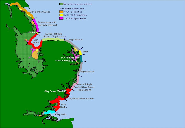
The Environment Agency - one of the GA's strategic partners - published a useful image of the flood defences as they were back in 1953 on a Pinterest board and it is shown below.
Image: Environment AgencyDownload the resource below:
More to come on this over the next few days. Look back at the posts from Southwold at the start of January as well for more related content to the floods, or search this blog using the search box top left.
There is also an associated Pinterest board.
I shall be out and about along the coast this coming weekend in a number of locations and will share some pictures in a Flickr album which I will share here.
I know there are permanent memorials in Hunstanton and Snettisham, and a search revealed one in Harwich. I would imagine there are others and would love to hear about them or see pictures of them if you know of one.
One was unveiled in Mablethorpe in 2013.
Another is in Felixstowe. This one has a blue line which marks the level of the flood waters which inundated large parts of the town.
Update
Although this has 'the North is coming to get you' vibes, it's really just a cumulative count of the population of England from north to south, as suggested by @BrownPhilip pic.twitter.com/tyjKoIG43D
— Alasdair Rae (@undertheraedar) January 26, 2023

Comments